
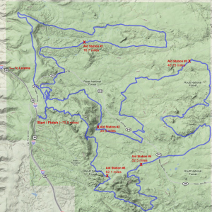
2010 Laramie Enduro Course – click image for larger view.
Course Notes:
Video
Pictures
More Pictures
And More Pictures
The 2011 course is very similar to the 2009 and 2010 courses with some minor re-routes here and there to avoid some really deep water – we didn’t think it would be a good idea for you to ride with flippers and a diving mask. Specific course details are available here.
Of note, there are several new bridges – unfortunately they are mandatory to walk across – be sure to listen to Kathy the Race Director for more info at the race start.
Just before Aid Station #2 there is a reroute at the bottom of Aspen Trail – be ready for it as it’s an about-face right hand turn. It’s a great little section of single track that’s mostly flat, then downhill – super fast, super fun! At the bottom, you’ll do a minor stream crossing (only about 2 feet wide and literally 2-3″ deep), then take a right towards station 2.
The next change happens after Aid Station #3 – there is a really sketchy singletrack that got washed out and to boot, it was located next to a barb-wire fence (yikes!). So there’s a new section of singletrack that’s – um, way cool! It avoids the rutted section for about 1/4 mile, then gets back on the original single track – note that this section is next to the fence, so be extra cautious.
The last change is a minor reroute prior to Aid Station #5 where there is a massive bog – with the reroute, you’ll miss getting wet and muddy.
That’s about it folks – have a great race!